


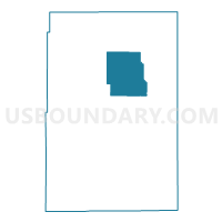
Yuma 12, Yuma County, Colorado
About
Outline

Summary
| Unique Area Identifier | 549432 |
| Name | Yuma 12 |
| County | Yuma County |
| State | Colorado |
| Area (square miles) | 139.58 |
| Land Area (square miles) | 139.49 |
| Water Area (square miles) | 0.09 |
| % of Land Area | 99.93 |
| % of Water Area | 0.07 |
| Latitude of the Internal Point | 40.15933530 |
| Longtitude of the Internal Point | -102.38061190 |
Maps


Graphs
Select a template below for downloading or customizing gragh for Yuma 12, Yuma County, Colorado


Neighbors
Neighoring Voting District (by Name) Neighboring Voting District on the Map
- Yuma 1, Yuma County, CO
- Yuma 2, Yuma County, CO
- Yuma 3, Yuma County, CO
- Yuma 5, Yuma County, CO
- Yuma 6, Yuma County, CO
- Yuma 7, Yuma County, CO